L1 - Intro to Hazardsa) Intro to Hazards PPT
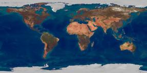
b) Global Hazards Interactive Map - click on the link above - look at all the hazards under 'past events' - in your book, describe the pattern of natural hazards for tropical cyclones, volcanic eruptions and earthquakes. - use these words in your descriptions: "highest and lowest concentrations" "geologic hazard" "climatic hazard" |
L2 - Hazards and Riska) Hazards and Risk PPT
b) Global Hazards Interactive Map - click on the link above (same map) - look at hazards risk under "risk" - describe the pattern of risk for earthquakes and tropical cyclones - use these words in your description " global pattern" / " areas most at risk" "regions of least risk" - comment on why some areas of the world are at greater risk than others |
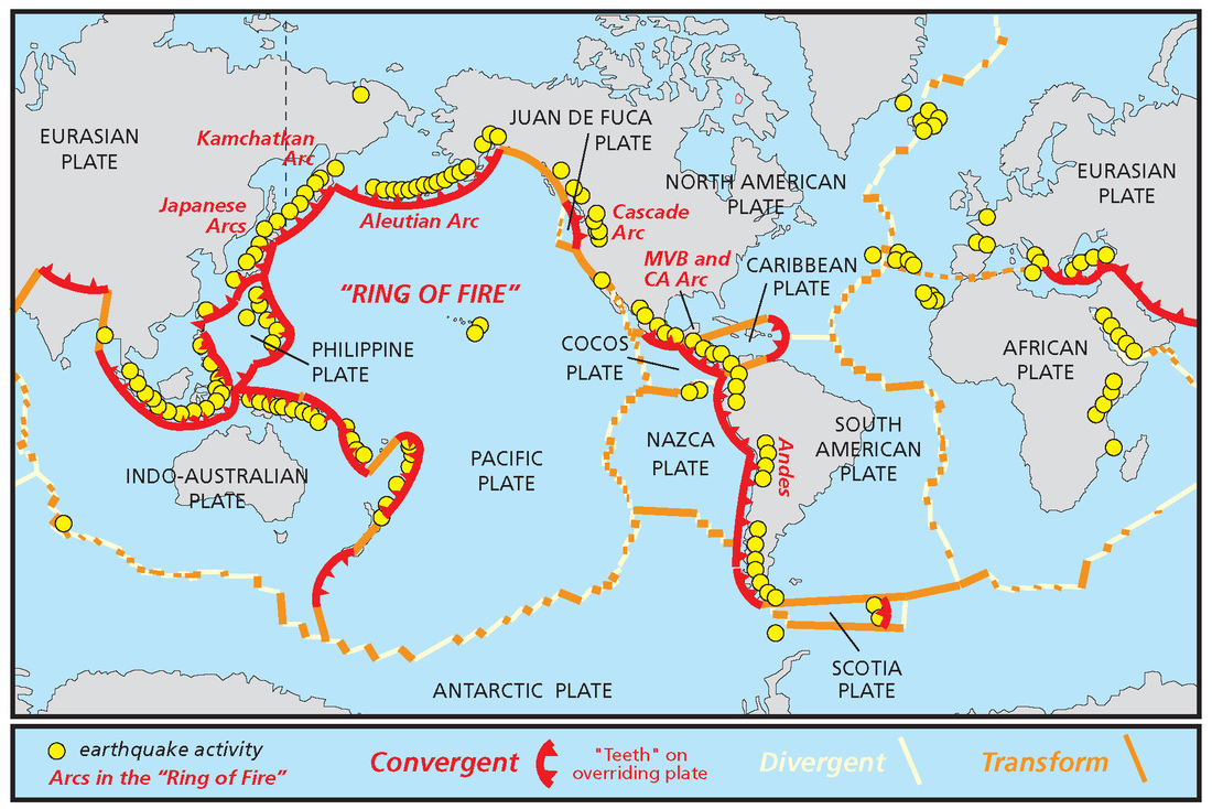
L3 - Plate Tectonics Review:
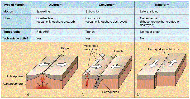
a) Plate Tectonics Review PPT (courtesy Bristol University) Must-Know Definitions from this Lesson: Transform Margin Constructive (Divergent) Plate Margin Destructive (Convergent) Plate Margin Subduction Hot Spot |
L4 - Plate Tectonics Maps
a) Complete a World Map of Plate Boundaries. Include the following: - Destructive Plate Movement - Constructive Plate Movement - Transform Plate Movement - 12 Major Plates - Two Volcanic Hotspots DUE FRIDAY OCTOBER 28TH 2015 For the Map we used in class, please see attached powerpoint: Plate Tectonics Map and Diagrams PPT |
L5 - Think You Know?
a) complete the Plate Tectonics Interactive and Challenge! "Delve into the earth's interior, learn about its tectonic plates and their movements, and discover how mountains, volcanoes, and earthquakes are formed." |
|
|
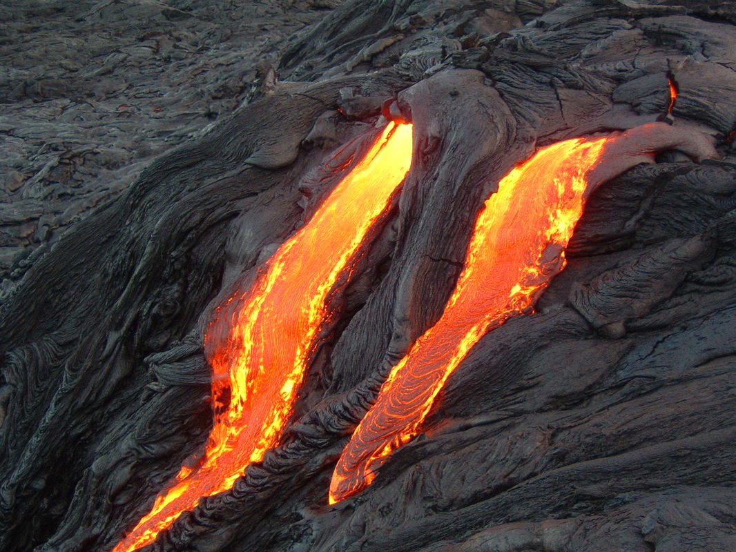
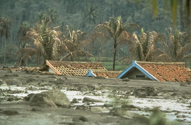
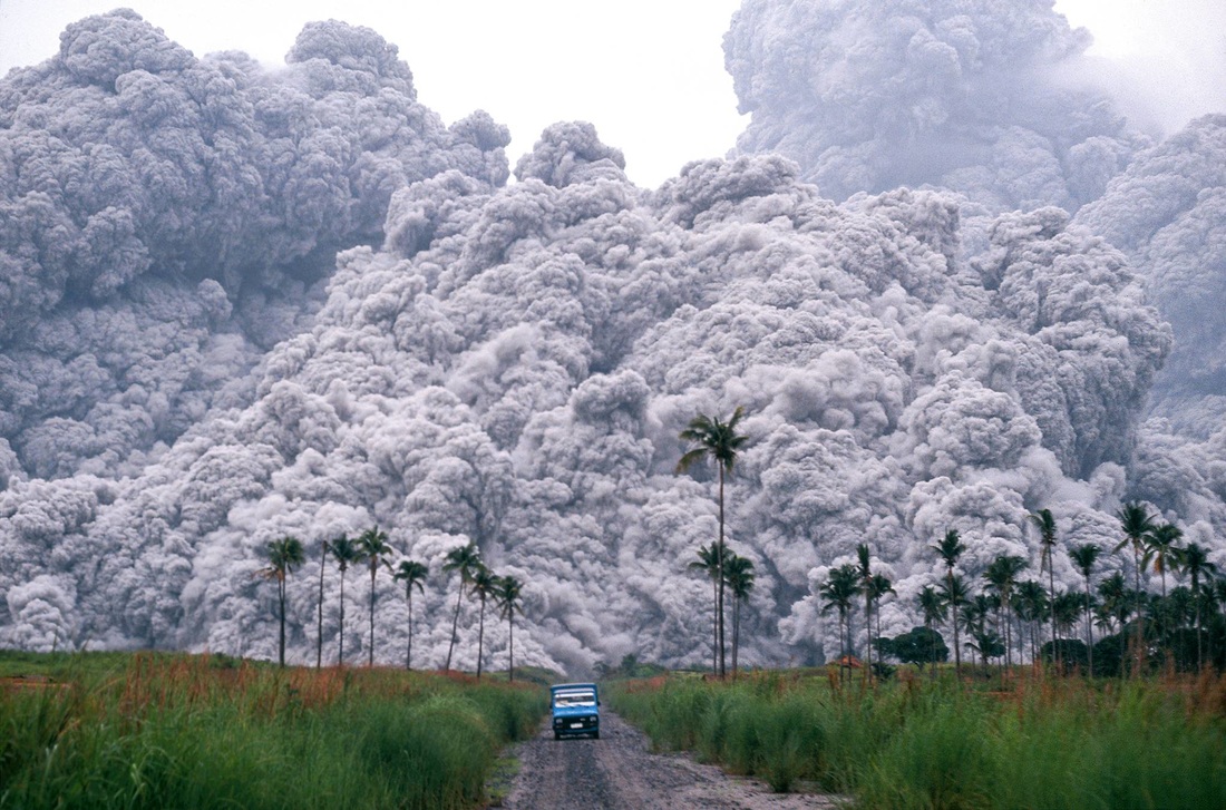
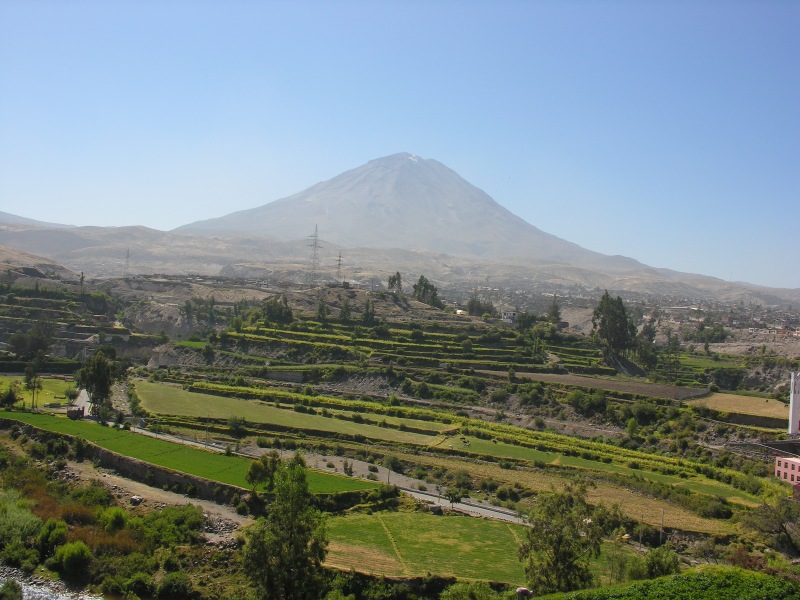
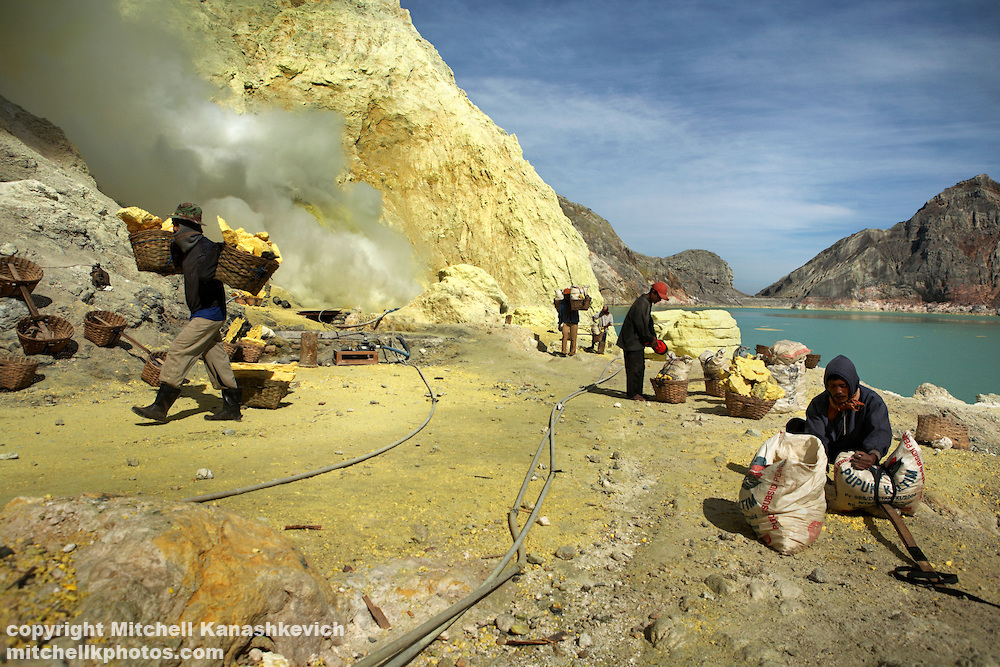
L6 - Montserrat Eruption Case Study "Soufriere Hills Volcano" The Caribbean island of Montserrat is situated on a destructive plate boundary. Underneath Montserrat the Atlantic plate is slowly being forced under the Caribbean plate. This happens because the oceanic plate is denser than continental plate. Convection currents pull the dense Atlantic plate into the mantle where intense heat and friction cause the rock to melt. This molten rock is lighter than the surrounding rock, forcing it to rise through cracks in the in the rock towards the earth's surface. ~ BBC Scotland Education a) The Montserrat Eruption Case Study PPT Ensure you know the following: 1. The location of Montserrat- you could include a sketch map 2. What caused the eruption? (type of boundary, plate names, process) 3. The type of eruption (lava, lahar, pyroclastic cloud etc) 4. Describe the short term (weeks afterwards) effects of the eruption 5. Describe the long term (years afterwards) effects of the eruption 6. How is the hazard of the volcanic activity 'managed' ? Was the volcano monitored? 7. Why did only 19 people die despite the dangerous eruption? |
|
L7 - Montserrat Eruption Response and Management
Today we play an interactive game where you decide how to manage this disaster based on the actual eruption timeline of the Soufriere Hills volcano. Download the map and the scorecard and listen while your teacher reads the helicopter reports from the 1997 eruption. Create and exclusion zone using the reports. After, we score your responses based on which measures were put into place. How well did you do compared to the safe responses of Montserrat authorities? a) Montserrat Eruption Scorecard ~ use to record the volcanic activity and decide on the best course of action b) Montserrat Map ~ use to record the location of the volcanic activity and decide on the exclusion zone c) Montserrat Eruption Overview PPT |
|
|
|
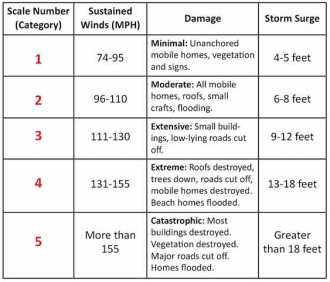
L8 - Rate the Quake! How Do We Measure Earthquakes? a) Introduction to Earthquakes PPT Most earthquakes occur along the edge of the oceanic and continental plates. When rock making up the plates underground suddenly breaks along a fault (plate margin) this sudden release of energy causes the seismic waves that make the ground shake. Need-to-know definitions: The Richter and Mercalli Scales b) Using the Richter and Mercalli Scales, click on the links below and find information to rate the earthquakes in your chart... Nepal 2015 Bam, Iran 2003 Kashmir 2005 Hawaii 2006 Japan 2011 California 2014 c) How often do earthquakes occur? See the map of Recent Earthquakes in California |
|
|
L9 - The Impact of Earthquakes
"Earthquakes don't kill people, buildings do..." a) Earthquake magnitude, fatalities and damages. Complete the worksheet to graph recent earthquake magnitude and location. Is there a correlation? b) The Impact of Earthquakes PPT c) Your assignment: International Committee of the Red Cross
|
|
L10 - Earthquake Preparedness
a) How many different things can a person do to prepare for an earthquake? (Vid.1) b) Earthquake Management PPT c) How does technology influence management? Design your earthquake-proof building! (Vid.2) |
|
|
L11 - Earthquake Predictions: More or Less Accurate than Volcanoes?
The 2009 L'Aquila earthquake occurred in the central region of Abruzzo, in central Italy. The main shock occurred on 6 April 2009, and was rated 5.8 or 5.9 on the Richter scale. Its epicentre was near L'Aquila, the capital of Abruzzo, which together with surrounding villages suffered most damage. There have been several thousand foreshocks and aftershocks since December 2008, more than thirty of which had a Richter magnitude greater than 3.5. 308 people are known to have died in the quake. After the earthquake, six Italian scientists and an ex-government official were sentenced to six years in prison... "L'Aquila Quake: Italy Scientists Accused of Manslaughter"
a) Using the article "Can We Predict When and Where Earthquakes Will Strike?" complete the following tasks:
b) Using the IGCSE Bitesize Revision website complete the following tasks:
c) Using the Volcano World website, describe four jobs geologists might do to predict volcanoes
d) Using all of the information above, answer: Is predicting earthquakes or volcanoes is more accurate? Explain your answer.
The 2009 L'Aquila earthquake occurred in the central region of Abruzzo, in central Italy. The main shock occurred on 6 April 2009, and was rated 5.8 or 5.9 on the Richter scale. Its epicentre was near L'Aquila, the capital of Abruzzo, which together with surrounding villages suffered most damage. There have been several thousand foreshocks and aftershocks since December 2008, more than thirty of which had a Richter magnitude greater than 3.5. 308 people are known to have died in the quake. After the earthquake, six Italian scientists and an ex-government official were sentenced to six years in prison... "L'Aquila Quake: Italy Scientists Accused of Manslaughter"
a) Using the article "Can We Predict When and Where Earthquakes Will Strike?" complete the following tasks:
- Write down four ways of predicting earthquakes from the BBC article
- Describe what exactly early warning systems measure. Judging from this article, are they successful?
b) Using the IGCSE Bitesize Revision website complete the following tasks:
- Record three ways of predicting volcanoes and two steps to making a management plan
- Describe how this prediction might be used to save people
c) Using the Volcano World website, describe four jobs geologists might do to predict volcanoes
d) Using all of the information above, answer: Is predicting earthquakes or volcanoes is more accurate? Explain your answer.
L12 - Earthquake Response: Abruzzo (Italy) in 2009 and Haiti in 2010 - What is the Difference?
a) Complete the HIC vs. LIC Response Sheet
b) Sort the causes and effects of the Haiti earthquake
c) How do the long term and short term effects of the two earthquakes differ? Watch the videos below
|
|
|
|
d) Your turn. To finish off our study of earthquakes and begin our study of hurricanes, complete both simulations in the ISDR's Stop Disasters game. Record the strategies available to you in the game. Record which ones worked best. Why was this the case?
|
L13 - Why and Where Do Hurricanes Form?
a) Intro to the Formation of Hurricanes Powerpoint b) Hurricane Interactive: Hurricanes in the Atlantic Ocean Complete your own cross-sectional hurricane diagram. Be sure to include the following labels: Edge of storm / vortex / eye / strong winds / ocean / cumolo-nimbus clouds / converging surface winds / high humidity intensifies storm / very low pressure / thunderstorms / torrential rain / dense cloud / less cloud / less wind and rain /calm c) How Do Hurricanes Form? Scientific American Video |
|
|
L14 - Tracking Hurricanes
14a) Hurricane Tracking Powerpoint 14) Hurricane Tracking Coordinates (and Questions!) 14c) Hurricane Tracking Recording Sheet |
|
L15 - Measuring Hurricanes
15a) Measuring Hurricanes PPT 15b) Stevenson Screen Handout 15c) Design a table you can use to record weather data on temperature, pressure, rainfall and wind speed. Track for one week, using the link... Weather Underground |
|
L16 - Effect and Response to Hurricanes in HICs
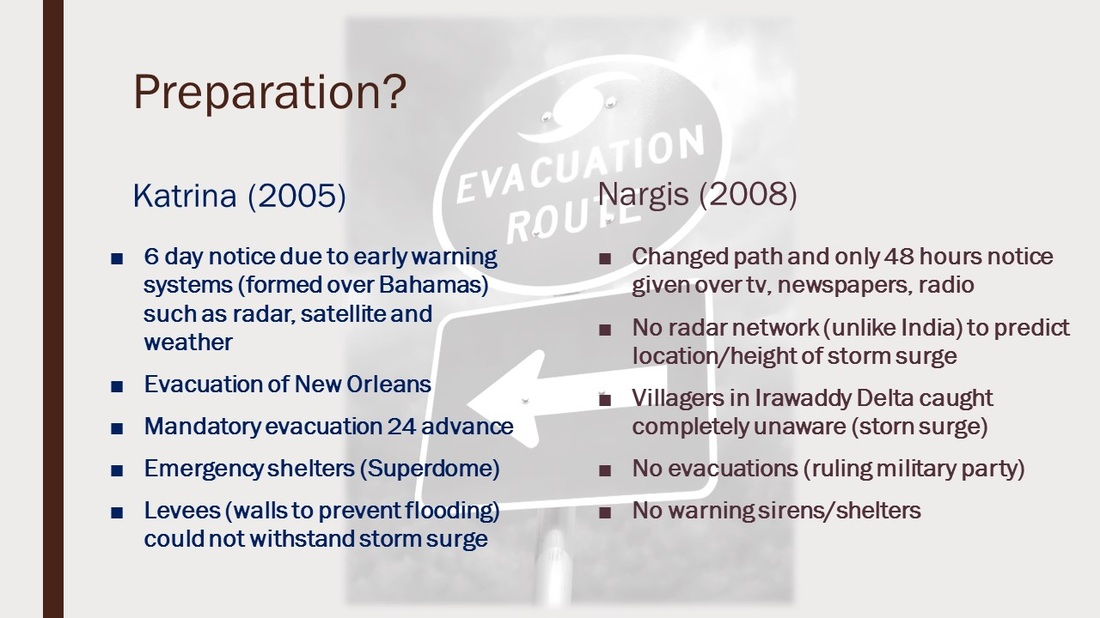
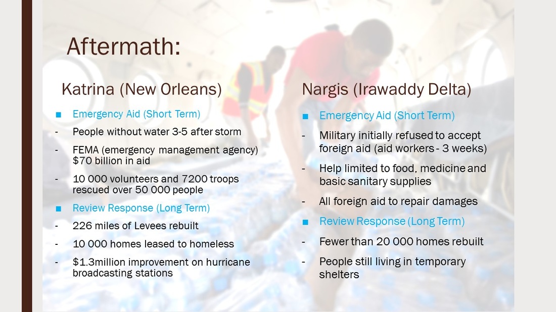
Hurricane Katrina 2005 - New Orleans, USA 16a) History Channel: Hurricane Katrina 16b) Answer the questions in this handout by reading the website above. Read the article and watch some of the videos available. 16c) Complete the Times-Pacayne "Flash Flood Interactive" and be sure to have your audio on! For each stage of the inundation describe where and which area flooded and how they flooded. You can draw or write this information. |
L17 - Effect and Response to Hurricanes in LICs
Cyclone Nargis 2008 - Myanmar (additional reading: NYTimes) 17a) Why Cyclone Nargis Was So Deadly - National Geographic 17b) Answer the questions in this handout by reading the website above. Read the article and watch some of the videos available. 17c) Complete the Guardian's Nargis Interactive detailing the devastation caused by this particular cyclone. Describe the path of the cyclone and the areas which flooded as the cyclone passed over. Detail some specific consequences in at least three areas or towns. |
|
|
